Up-to-date and high resolution digital elevation model and digital surface model give possibility of generating spatial visualisations small areas as playing fields as well as counties or regions.


- an image giving the illussion of three-dimensional
- raster pdf, jpg or tiff format files
- size from 10×10 cm to 1,5×1,5 m, resolution appropriate to final usage
- licence for number of copies, volume or unlimited
- design fitting needs of the client
- the map or aerial photo as a background, drapped onto the digital elevation model
- thematical data from the client as a foreground
- view from specified point or an aerial view
- view including or not real surface
- natural or artificial colours, highlighted essential attributes of the terrain or three-dimensional objects
- typical map of the region contained by the visualisation, facilitate orientation – as an add-on
- geographical names on the image, descriptions of objects, results of geodetical measurements and other
- possibility of usage in land use planning or investment process
- possibility of usage in promotion of touristic values
Samples of the offered visualisations:
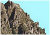
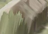
| 2,5D view with aerial photo |
 |
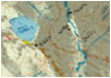
| 2,5D view with touristic map |
 |
| 2,5D view with topographical map |
 |
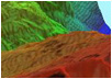
| 2,5D view with topographical map and colour hipsometry |
 |
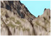
| sky-line from specified point with aerial photo |
 |
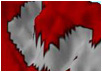
| range of the visibility from the point |
 |
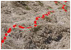
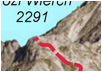
| excursion route |
 |
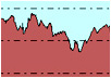
| vertical profile |
 |
| 2,5D view with buildings |
 |
| 2,5D view with descriptions |
 |